Here is some great info about the weather from a neighbor:
The U.S. Weather Bureau for the metro Denver area is
located in Boulder, and has more people working the
forecasts than anyone else. Go to:
Weather.gov
The buttons give a variety of information. The official
forecast is gotten by pushing "Zone Forecast" (then
use your browers "Find" function to search for "Ned").
This forecast is updated several times a day, but most
significantly around 4 a.m. and 4 p.m. (only in
unusual circumstances, like today, is it updated
more frequently).
The "Short term forecast" is updated every 3 hours
or so and is more immediate. Look for the part that
includes Nederland. During calm periods, nothing
is posted here.
During periods of potentially bad weather situations,
click on the "Warnings and Advisories" button. During
threatening situations, this is updated every 6 hours
or so. An alternative is the "Special Weather" button,
which is often changed during morning hours more
frequently than the "Warnings...".
For those who really want to understand what to
believe about the official forecasts, the really
special button is "Forecast Discussion". While
this discussion (be sure to go to the Denver
discussion, rather than Grand Junction, Pueblo,
or Goodland) is filled with abbreviations and
technical jargon, the forecasters let their hair
down and tell you about their confidence (or lack
thereof) of the forecasts. Anyone can get the gist
of what's in their minds, behind the official
forecasts, despite the jargon.
For example: last week's storm was confidently
predicted 48 hours in advance, and the "Discussion"
indicated confidence that the storm would happen in
the way it actually did. This storm, that seems
to be ending in our area, had great uncertainty
for the last 5 days. If you read the
"Discussion", it was clear that this meteorological
situation was unprecedented, involved inherently
unpredictable aspects, and the official forecasts
were extremely uncertain. For us, added to the
general uncertainty, is the fact (apparent from
the Discussions) that we have been on the western
fringes of the storm. If it had moved (and, still,
if it might move) a hundred miles to the west, we
could get a lot more snow. But if it moves a
hundred miles to the east in Kansas/Oklahoma,
then we're finished with the snow.
No matter how much you might like Mike Nelson's
personality, he is mainly just giving a "popular"
account of this official forecast. Some media
outlets subscribe to other services (like Accuweather)
which, I believe, are less reliable. For the March
2003 7-foot storm, United Airlines relied on
Accuweather, which predicted snow flurries for
Denver, and flew all its planes into DIA to be
stranded. I relied on the Weather Bureau, which
predicted a possible "storm-of-the-century" in its
forecast "Discussion" 36 hours before the first
flake fell, so I loaded up with supplies. Somne
media simply aren't savvy. KUNC radio, for
example, hasn't figured out when the new forecasts
are issued. So KUNC reported around 5 o'clock
that we would get another foot of snow tonight,m
relying on the official forecast written before
dawn and not realizing that the usual afternoon
forecast (available between 3 and 4 pm) had
downgraded the snow forecast.
I hope this is helpful. Although I am a professional
astronomer, I actually have a Master's Degree
in meteorology and have long been interested in
the weather...so there is a bit of professional
backing to my recommendations.
For the next few days, however, we're happily
stranded by all the snow in our driveway.
Happy New Year!
Clark (& Y) Chapman
Saturday, December 30, 2006
Friday, December 29, 2006
3 feet of snow and counting
Earlier today I measured 21 inches of new snow and a total of almost 3 feet of snow. And there is supposed to be more on the way.
I heard that you'd have to go back to 1913 to find another instance of two back to back snow storms like this.
In Boulder, they have the concept of a 100 year flood for the flood plane.
Up here, we seem to be experiencing a "100 year" snow.
I heard that you'd have to go back to 1913 to find another instance of two back to back snow storms like this.
In Boulder, they have the concept of a 100 year flood for the flood plane.
Up here, we seem to be experiencing a "100 year" snow.
Thursday, December 21, 2006
Plowing the driveway using heavy equipment
As I mentioned in yesterdays post, when the snow gets to deep, its time to call in the heavy equipment. We called High Country Excavating because they've given us a fair deal in the past.
The neighbor that usually does our driveway was stranded coming back from Florida, so the snow got to be 2 feet deep in the driveway. This is very difficult for a regular residential grade snowplow to handle.
If you look carefully at the opening sequence in the video below, you'll see that the front end loader had to PUSH his way UP the driveway using the backhoe. This is obviously not a maneuver that is available to a pickup based snowplow.
Wednesday, December 20, 2006
I'm dreaming of a white Christmas.
Here is a response I sent to the Puma email list after Terry Greenberg asked about plowing services:
Hi Terry and all,
This is starting to feel like the storm that started on March 15,2003. Contract residential plowing services could not handle it. It took earth moving equipment to dig me and a bunch of neighbors out.
The problem is that standard plowing equipment can't handle more than about a foot of snow. We're working our way up here to two feet now. Once you've got more than a foot, it becomes difficult for a residential snow plow to get through, especially on long uphill driveways.
I just put in my call to High Country Excavating. Last time, spring came to the rescue. The snow may not get as deep this time, but its not even Christmas yet.
Who wants to fess up to singing "I'm dreaming of a white Christmas" ONE TO MANY TIMES!?!
- Mike
Saturday, December 16, 2006
Thorodin in the news
Yeah.
Thorodin made the news. It's just a little bit about hiking Thorodin in the Fiday December 15 edition on page 3B of the local Daily Camera, but its something.
The problem with climbing Thorodin is that the one trail to the top was blocked of years a go by a zealous land owner at the trail head. Another possible route goes up a private jeep track that has a "no tresspassing" sign. The jeep track is used to maintain the 2 story antenna farm that is on the top of Star Peak (part of Thorodin)
The suggested trail in the Camera article starts at Panorama Point in Golden Gate State park. It then suggests a moderate bushwack 1.5 miles and 1200 foot elevation gain to the top. It recommend the hike because of the view. I'll second that recommendation.
Sunday, November 19, 2006
A friendly neighbors experience and advice about mountain lions
Dear Pumites All:
Over here at Twin Sisters we have regular mountain lion presence as well. Tracks mainly, but also, scat and occaisional sightings and even one encounter.
Roz came home around midnight a few years ago, to find that a mountain lion had treed a racoon or something right in our parking lot. It was roaring, and stayed at the base of the tree forat least a half an hour. A thrilling basso profundo roar, a bit like the Metro Goldwin lion. I was listening out the upstairs window. Roz stayed put in her car. Finally, a long time after the lion stopped roaring, Roz made a dash for the house.
Another time I was gazing idly out the bedroom window at the meadow in the moonlight, 10 pm or so, when suddenly one, then two more deer came tearing across the meadow, east to west, just above the garden, followed immediately by the long, low to the ground outline of a mountain lion, long tail out behind. The whole group was moving at top top speed, the lion maybe thirty yards behind the three deer. Just past the garden the deer cut an impossibly abrupt left turn, downhill, which the lion matched as best he could, (I think he lost some ground to them), then the whole show disappered down below our barn, and that was the last I saw of them. The whole thing was in complete silence. I found a few tracks in the morning, to confirm I hadn't been dreaming, but I am a very lazy tracker, easily bored, so I didn't try to map it all out.
Anyway, we see tracks, every year a handful or so of times up on Twin Sisters. Most recently, ten days ago in one of the fresh snows.
The Antidote to Lions. Roz and I gradually became a little uncomfortable about this definite presence of lions, particularly since we often hike alone, and at dusk. So we have taken to sometimes carrying a super potent can of pepper spray with us. My limited research on this subject leads me to believe that this pepper spray is the best thing you can do for yourself in case of a real life lion encounter. I think this is the consensus among wildlife biologists as well.
The spray was designed as an antidote to grizzly bears, and is used most frequently in Alaska, where almost everyone carries it in the back country. You can buy it at McGuckins for about $40 a can.
VDAP Pepper Power- Bear Deterrent.
Of course it would be useless if you were surprised in an ambush, and it could be counter productive if there was significant wind moving agaInst you. But in a lot of mt lion encounters, wind isn't a problem, and there's plenty of time to get organized to defend yourself. In such cases the spray could make a real difference.
I find it sort of comforting to have along in a back pocket, whenever I think to bring it. And as for muggers, gangs, or maurauding packs of wild dogs or wolves, you're covered.
Well, that's the news from Twin Sisters, John & Roz McClellan
Saturday, November 18, 2006
Re: [puma-news] New Mt. Lion
On Mountain Lions.....thank you, Yvonne, on the update from Colleen,
I have been seeing signs of lions in this area for several years...
tracks, scat and kill signs. I have frequently seen their scat along 68
and Cumberland, as well as up around Forsythe and the elk trails through
the woods near Winiger. Two years ago I watched a lion as it walked
through the woods by my studio on a bright, spring afternoon. Beautiful.
Females can breed any time of year....having no set season. Although
they can roam very large distances, they tend to hang around when there
is ample food (resident deer, elk....even an occassional bobcat, raccoon,
rabbit, mouse, or ground squirrel). They are known to hunt during
anytime of the day or night, tending to ambush their prey and therefore
preferring lots of brush or rock outcroppings for cover. When I am out
hiking in these types of areas, I just try to remember to be extra aware.
They do not like to associate with other lions (except for mating), and
are very territorial, I think it would be unusual if there is more than
this one in the area.....at least on most occassions.
I feel so fortunate to live in an area where lions co-exist alongside
me......with so many of Nature's predators being villified and destroyed,
I remain somewhat hopeful whenever I am reminded of their presence here.
Sharon Ticehurst
On Fri, 17 Nov 2006 14:21:22 -0700 George Blakey <ysgb@earthlink.net>
writes:
> Hi all,
> Colleen Canon wanted me to send out an email just to let neighbors
> know
> that in our area of Aspen Meadows and down 68, she has been seeing a
>
> very large lion that usually doesn't hang around here. As they are
> out
> all the time it is good to be aware and not paranoid about this.
> She has seen it at her house around 6:30 P.M. and said that one of
> her
> horses has been trying to dig it's way out of the enclosure down in
> the
> lower meadow, she will be leaving it free for now.
> She thinks that since West Magnolia has been closed to the hunters
> this
> year and that there has been a lot of killing of deer/elk? up behind
> us
> that the lion may have been drawn by the smell, also don't know when
>
> their mating season is, but that could be an affect as well.
> Just a heads up for those who enjoy a walk in the evening.
>
> Yvonne Short
>
>
>
Tuesday, November 07, 2006
[puma-news] Burglars
Turns out that they caught two guys yesterday. My guess is that they are not
the ones actually doing the break-in (that was a man and woman), but were
hauling away the loot.
http://www.co.boulder.co.us/newsroom/templates/?a=659&z=2
Let's hope that puts the fear of the law in the other two, or even better,
the first two roll over on the second two.
John,
~ the chart guy
John Carder, CMT
Topline Investment Graphics
Where your chart dreams come true!
www.topline-charts.com or www.chartguy.com
PO Box 2340
Boulder, CO 80306-2340 USA
800.347.0157 (toll-free in the USA)
303.440.0157 (voice)
303.440.0147 (fax)
Sunday, November 05, 2006
[puma-news] Magnolia Road, runners, and politics
Hello all,
I'm certainly not one of the slowest drivers on Magnolia, but I have to say that I love seeing runners up here...it reminds me that we live in a place that lots of people appreciate...and I have no problem at all getting down to 10 MPH before getting particularly close to them (not just to avoid hitting them but to avoid getting a lot of dust in their eyes.)
As for the school bus, my couple of experiences with it (I usually go to work before it's around) did involve fairly long waits behind it, but the driver was very good about pulling over to the side for me and others to pass very shortly after all the kids had boarded.
Other than the dust issues, I don't think it's particularly hard for us all to use Magnolia, on foot, or bike, in car or bus.
Also, as many of you know I'm quite politically active (maybe not in directions you all agree with.) I don't want to start a political discussion on this news group, but I would like to ask you, if you're interested, to take a look at my blog at http://www.rossputin.com and have a read about my voting recommendations/endorsements. My guess, assuming something about the politics of most Magnolia residents, is that the typical PUMA reader will disagree with something more than half of my suggestions and agree with something less than half. If you go to http://www.rossputin.com and click on the "Colorado Issues" category (scroll down a bit to see the categories below the calendar), you can start with the 10/31 posting and work back up from there. Even if you disagree with me, I hope you'll find my discussion and analysis interesting. I have written an endorsement or suggestion for every state-wide position, Referendum, and proposed Constitutional amendment. I have not written anything on individual State House or State Senate seats or local (county or city) ballot measures.
I would just like to mention that Mark Hillman, running for State Treasurer, is a good friend of mine, an incredibly solid person, talented and conscientious and experienced in dealing with and balancing state budgets, and (not that it matters for Treasurer) much more live-and-let-live on social issues than one would expect from a Republican these days. Maybe it's because he's a farmer by trade. I hope that those of you who typically do not vote Republican will consider a vote for Mark. (Tomorrow I'll have a piece on my blog about more specific reasons to vote for him, though I already have much of that in the 10./31 candidate endorsement posting.)
Beyond that I will hope that you read my blog and I would be happy to discuss politics or issues or candidates with any of you in a private email conversation if you're interested.
Have a great Sunday, everyone!
Ross K
Terry Greenberg wrote:
To All:
I agree. I even run or perhaps its called "woddle" on Magnolia and love it. I have even put my dog on a leash and we run single file and I love running with the champions, for a split second. That's great. I never ever mind the runners on Magnolia and happily slow down for them too. And I think running on the dirt has allowed my knees to keep on keeping on just fine. Yay Magnolia.
Terry Greenberg
At 07:56 AM 11/3/2006, Kevin Seeman wrote:
As an avid runner who used to train for speed, I have at least a partial explanation for the elite presence on Magnolia as opposed to our vast trail system. Access is a huge part of it, as the coaches can stage in Boulder and have their team stretched, warm and ready to run in 30 min. Of course, they want to run at altitude to maximize their training. Magnolia is ideal because they can set up any number of training routines, including timed speed work, time trials, tempo runs.... And while it may be dangerous as far as traffic, it offers perfect footing. You get to run on dirt without the variables of the trail (roots, rocks...), it is well maintained, snow is removed quickly, it dries out rapidly. Coaches can drive along with their team to offer support and watch their runners' form. And for the runners, it helps to train with your team, running along with your partners, helping each other through rigorous training sessions, as opposed to being strung and scattered along a trail.
I run and bike on Magnolia with my wife every week year round. I also commute to the flats every day. In my opinion, we all have to share the road, and it is ultimately the drivers' responsibility to be aware, cautious and safe. I love seeing the Olympians running our beautiful road, even if I do have to slow to a crawl to pass a pack.
Regards,
Kevin Seeman
From: Craig Irwin <Craig.Irwin@sun.com>
Reply-To: Craig Irwin <Craig.Irwin@sun.com>
To: Allen Gordon <gordona@mric.net>
CC: Fay <fay@mric.net>, "'PUMA News'" <puma-news@www.puma-net.org>
Subject: [puma-news] Re: Magnolia mentioned in NY Times article
Date: Thu, 02 Nov 2006 08:25:46 -0700
It is neat that Magnolia got some NY Times press.
We need to consider how PUMA will advise or improve upon the following
regular occurrence.
Here is the real daily scenario: (keeping in mind that all users of the
road believe that they have a 'right' to use the road.
Parents drive the car with kids up to the bus stop, any School bus stop
on Magnolia Road, approx 8 cars pulled over on the side of the road
waiting on the bus.
* Inbound to the same location from the east, (just around a blind
corner) is a group of 14 road runners, running four abreast on the road
in the middle of the road with no concern nor awareness of other users
of the same road.
* Inbound to the same location from the west, one driver with one hand
on the cell phone the other hand occasionally juggling hot coffee,
running late to an appointment, headed around a blind corner converging
on the school bus stop at 40+mph. This driver will be forced into the
oncoming traffic lanes so as to avoid the cars and people pulled out at
the bus stop.
* Also eastbound is a Lumber Truck loaded with a delivery, driver has
been patiently waiting to pass the Japanese running team for two miles
and is now ready to make his move. He too will be forced into oncoming
traffic lanes as he approaches a corner.
What happens next?!
---
Really this is not a case of 'who is right?' nor 'who is wrong?'. Sure,
the cell phone driver is acting irresponsibly, but thus far, we have
been unable to eliminate the irresponsible members of society, so we
must accept their presence.
This is a case of competing multiple uses where each individual is
equally responsible for their actions.
While county planning has obviously not occurred in order to create a
safe spot for School Bus pickups, perhaps communication to the runners
that Boulder County has hundreds of miles of well maintained trails
ready for their use might be a good start. Why run on a busy road when
you have unlimited trails to run on?
The road runners are clearly not coherent as to the risks that they are
shifting to the other road users when they run in any form other than
single file.
I truly hope that this situation does not end in a fatality, but rather
the community will come together to creatively solve this situation by
way of education and safe behaviors.
The older I get, the slower I drive.
-Craig
Allen Gordon wrote On 10/31/06 07:25,:
Having run on Magnolia, the crown of the road makes it difficult to run
on the sides--the slope of the road twists the ankles. Additionally,
I've found that when approaching a blind curve, running on the inside of
the curve can be dangerous because of the lack of visibility--thus
making it safer to run with the traffic if that side is on the outside
of the curve. Finally, I think there is a bit more traffic in Boulder
than on Magnolia Rd. Perhaps the larger problem is how people drive on
Magnolia Rd, not how people run. One problem that I've noticed is that
people stop their cars in very inopportune places during times when kids
are picked up for school. For example, many folks wait in their stopped
cars at the top of the hill at Magnolia and Frontier in front of the
mail boxes. Cars attempting to pass them have to drive blindly on the
wrong side of the road not knowing if another car is approaching on the
other side of the hill. Similarly at Pine Glade and Magnolia. Cars are
stopped such that cars coming from Pine Glade onto Magnolia must do so
with very limited visibility of approaching cars. Of course there are
many who drive pretty fast exceeding the 30 mph speed limit. Those darn
runners make it difficult to drive fast because they are either running
in the middle of the road, on the wrong side or side by side.
Allen
Fay wrote:
Now if they could only learn to run against traffic, single file, and on the
side (as opposed to the middle) of the road, they would all live long enough
to compete! Funny, same rules they follow in Boulder but don't seem to
apply up here.
Fay Benson
-----Original Message-----
From: owner-puma-news@www.puma-net.org
[mailto:owner-puma-news@www.puma-net.org] On Behalf Of Greg Ching
Sent: Tuesday, October 31, 2006 1:30 AM
To: PUMA News
Subject: [puma-news] Magnolia mentioned in NY Times article
I think most Magnolia residents know we have world class athletes
training on our road but it's still neat to see Magnolia mentioned in
the NY Times. The complete article can be found at
http://www.nytimes.com/2006/10/31/sports/othersports/31boulder.html?hp&ex=11
62357200&en=94ec7cc5b064ac1d&ei=5094&partner=homepage
I'm only copying here the first few paragraphs...Magnolia mentioned in
third paragraph.
greg
October 31, 2006
In Boulder, Runners Gather in Guarded Isolation
By LIZ ROBBINS
BOULDER, Colo. - Here at 5,430 feet, all roads lead to a finish line
somewhere. They just rarely converge.
As the major marathon season hit its fall peak, professional distance
runners from Kenya, Japan, Romania and Tanzania, as well as the United
States, were pounding the dirt roads in Boulder for a high-altitude boost.
Long a popular haven for elite athletes, the area boasts 300 sunny days
a year, 400 miles of trails (including Magnolia, which soars to 8,600
feet), more massage therapists than muscles and a fervent outdoor culture.
But this is no running utopia. Instead, Boulder is an example of the
fiercely competitive sport of road racing, in which runners train in
quiet isolation, passing one another occasionally on hills while
guarding their strategies.
Competitors from around the world may come here, yet the various camps
operate in their own universes. With schedules dictated by agents,
runners compete not just for the podium, but for a relatively small pool
of resources, shoe contracts and race appearance fees. It is a scene
that is more clannish than collegial.
Tuesday, October 31, 2006
Magnolia Road famous for World Runners
In the summer and fall we do get a lot of runners on Magnolia Rd. I did not know how famous this road is for world class runners until I read about it in the NY times.
I have reprinted the the article below, with a highlight of the most relevant part.
Consider one typical brisk Boulder morning in early October. Dathan Ritzenhein, 23, the United States’ latest prospect, prepared for his marathoning debut in the New York City Marathon on Nov. 5 by repeating 10 hill sprints. Alan Culpepper, 34, a fellow 2004 Olympian and University of Colorado alumnus, was running a suburb away.
“The marathon will be the first time I’ve raced Alan since my senior year in high school,” Ritzenhein said Oct. 9. “We live that close and we’re in the same sport, but our paths don’t cross. It’s kind of strange.”
Elsewhere, Japanese women peeled off matching cinnamon warm-ups and embarked on runs from the Boulder Reservoir. One of the women wordlessly passed a group of Kenyans on a 25-kilometer training run.
The Kenyans’ German coach, Dieter Hogen, barked encouragement, and the former marathon champion Uta Pippig echoed it, shouting, “Keep a good rhythm, guys!”
Hogen had once led Pippig out of East Germany and eventually to Boulder, coaching her to multiple marathon titles in the 1990s. She was barred for two years for failing a 1998 drug test that was later ruled inconclusive, and now she helps runners in Boston and Boulder.
Hogen runs Camp KIMbia, in operation since 2003. It may raise eyebrows for its isolation, but a few miles away Anuta Catuna of Romania was showing off her new house and pointing to one across the road that belonged to the 2000 Olympic women’s champion, Naoko Takahashi. Catuna, the bubbly 1996 New York champion who is trying to become a United States citizen for the 2008 Olympic trials, trains and socializes with other Romanian runners living in Boulder.
To old-timers, segregation is an unfortunate development. “I think all these guys are doing a disservice to each other,” said the South African marathoner Mark Plaatjes, who owns the Boulder Running Company, a small chain of shoe stores, and a physical therapy business. “They are missing out on the collective knowledge, the experiences.”
Frank Shorter, the American marathoner who popularized the sport by winning the gold medal in the 1972 Olympics and the silver in 1976, was the first to settle in Boulder.
“It was the only city with an indoor track at 5,000 feet,” he said in a telephone interview. “There were 10 committed runners in town, but I was the only real athlete training.”
Shorter set the pace. In 1987, Plaatjes came to raise his children without apartheid and to run with other champions: Steve Jones of Wales, Rob De Castella of Australia, Arturo Barrios of Mexico and Priscilla Welch of England.
“We used to meet at each other’s houses; there would be 30 guys and 20 countries represented,” Plaatjes said outside his store. “We’d go out for a run, beat each other up and then drink a beer afterwards.”
Collegiality now thrives in Boulder during the afternoon when the Africans drink chai together. Teamwork is paramount in daily chores or on the course, whether they train to set the pace or to win.
“It is very good to be in a group, because in training you need to simulate running,” said Thomas Nyariki, wearing sunglasses during an interview to protect his right eye, which was blinded in a 2003 carjacking in Kenya. He will race New York, having won the city’s half-marathon in August.
Hogen runs his camp with wry humor and unwavering discipline, coordinating runners’ workouts according to their marathons: Chicago, New York, Amsterdam, Frankfurt and Dallas.
The runners leave their families behind and immerse themselves with Hogen, “because of his experience; he knows how to train hard,” Nyariki said, adding, “We go two weeks hard, one week easy.”
Hogen founded the KIMbia (“to run” in Swahili) management company with Tom Ratcliffe, an agent based in Boston.
“These guys all have real good backgrounds,” Hogen said, explaining that he chooses runners who were not necessarily famous but had success at shorter distances. “They come with the thing you want to see — a commitment to working hard.”
A Mecca for Marathoners This year at Hogen’s camp, as many as 18 men and 2 women from Kenya and Tanzania have shared four apartments, which include facilities for physical therapy and laundry and, in one concrete backyard, a hot tub that overlooks an office park.
The athletes usually train twice a day. In the afternoon, they make their sugary milk tea in a spaghetti pot, watch television and play checkers in a living room decorated with prize plaques. At night, they cook ugali, a Kenyan stew poured over a cornmeal mixture.
Hogen said the camp had no secrets, and pointed out that it was featured on a Web site by a freelance writer (chasingkimbia.com). But the camp raises questions among some in Boulder because of Hogen’s connection with Pippig.
“The case was dismissed; they couldn’t prove anything, and that was the end of the story,” Pippig said, referring to her 1998 drug test. “And believe me — I couldn’t work with anyone if I did it.”
She added of the Kenyans, “For these guys, drugs play no role.”
Shorter, the former chairman of the United States Anti-Doping Agency, said Hogen’s camp raised a general concern that foreign athletes went to Boulder to dodge testing.
“My only question would be: How often are the Kenyans training in Boulder tested?” Shorter said, urging marathon directors to control prerace testing. “You have to set up a system so you don’t have to be suspicious.”
Ratcliffe said his athletes were clean. They register their whereabouts with the International Association of Athletics Federations and can be subject to random testing by USADA and the World Anti-Doping Agency.
“I would love for them to come every day,” Ratcliffe said. “People see East German intrigue, but it’s just not the case.”
Ritzenhein said that distance running was not “that dirty of a sport,” and that no American distance runners used drugs. He said that he spoke of the topic daily with his Boulder teammates, the twins Jorge and Ed Torres (the three helped Colorado win the N.C.A.A. cross-country championship in 2001) and Jason Hartmann, a high school teammate from Rockford, Mich.
This year, the New York Road Runners donated $240,000 to support running camps in the United States, including $115,000 to one in Mammoth Lakes, Calif., where the Olympic medalists Meb Keflezighi and Deena Kastor train. Ritzenhein’s coach, Brad Hudson, a former distance runner at Oregon, received $45,000 for his Boulder Performance Training Group.
On training runs, Hudson follows Ritzenhein in a tan 1983 Volvo he bought last summer. Hudson does not accept money from Ritzenhein, he said, to eliminate conflicts of interest with sponsors.
But the allocation, filtered through USA Track and Field, caused some resentment. Steve Jones coaches a young group in Boulder that was not financed. He said he was frustrated because Ritzenhein already received sponsorship from Nike.
“I believe we need to work within reality,” Mary Wittenberg, the chief executive of the Road Runners said in a telephone interview in late October. “We are best served in funding kids coming out of college who have the best shot of winning gold medals. We’re beyond being just the best American now.”
America’s past looms in bronze at the base of Colorado’s Folsom Stadium. Every May, nearly 50,000 runners from around the world pass by a statue of Shorter on their way to the finish of the 10-kilometer Bolder Boulder. Shorter was a co-founder of the race in 1979, and it defined the city as an outdoor Mecca.
Alpinists, triathletes and mountain bikers train here, though perhaps not to the extremes of the running cult Divine Madness, whose members pool their earnings, live ascetically and run ultra races. “We’re not all like that,” Culpepper said.
Children seem to have inherited the running genes; Boulder High School’s cross-country team fielded 135 boys and girls for the second consecutive year.
Stickers convey Boulder’s maximum heart rate: “Don’t Die Wondering” and “Remember to Breathe.” The Go Fast energy drink truck rumbles through downtown.
Running utopia is not yet here. Mark Wetmore, the coach of the nationally ranked Colorado cross-country teams, limited the stadium’s public track hours to preserve its surface four years ago. With no central meeting place, elite runners do track work at different high schools. This makes Plaatjes dream.
“I want to buy a plot of land and build a clubhouse and have a training room, with trails out back,” he said. “A facility where there is a bar and a sitting area, like in Europe.
“I know this sounds corny,” he added, “but I really think, ‘If you build it, they will come.’ ”
But will they come at the same time?
.
Re: [puma-news] Magnolia mentioned in NY Times article
Good call Allen
It shouldn't be too hard to slow down for runners, cyclist, walkers, horses,
choldren etc
>From: Allen Gordon <gordona@mric.net>
>Reply-To: Allen Gordon <gordona@mric.net>
>To: Fay <fay@mric.net>
>CC: "'Greg Ching'" <greg.ching@mric.coop>, "'PUMA News'"
><puma-news@www.puma-net.org>
>Subject: Re: [puma-news] Magnolia mentioned in NY Times article
>Date: Tue, 31 Oct 2006 07:25:05 -0700
>
>Having run on Magnolia, the crown of the road makes it difficult to run on
>the sides--the slope of the road twists the ankles. Additionally, I've
>found that when approaching a blind curve, running on the inside of the
>curve can be dangerous because of the lack of visibility--thus making it
>safer to run with the traffic if that side is on the outside of the curve.
>Finally, I think there is a bit more traffic in Boulder than on Magnolia
>Rd. Perhaps the larger problem is how people drive on Magnolia Rd, not how
>people run. One problem that I've noticed is that people stop their cars
>in very inopportune places during times when kids are picked up for school.
> For example, many folks wait in their stopped cars at the top of the hill
>at Magnolia and Frontier in front of the mail boxes. Cars attempting to
>pass them have to drive blindly on the wrong side of the road not knowing
>if another car is approaching on the other side of the hill. Similarly at
>Pine Glade and Magnolia. Cars are stopped such that cars coming from Pine
>Glade onto Magnolia must do so with very limited visibility of approaching
>cars. Of course there are many who drive pretty fast exceeding the 30 mph
>speed limit. Those darn runners make it difficult to drive fast because
>they are either running in the middle of the road, on the wrong side or
>side by side.
>
>Allen
>
>Fay wrote:
>>Now if they could only learn to run against traffic, single file, and on
>>the
>>side (as opposed to the middle) of the road, they would all live long
>>enough
>>to compete! Funny, same rules they follow in Boulder but don't seem to
>>apply up here.
>>Fay Benson
>>
>>-----Original Message-----
>>From: owner-puma-news@www.puma-net.org
>>[mailto:owner-puma-news@www.puma-net.org] On Behalf Of Greg Ching
>>Sent: Tuesday, October 31, 2006 1:30 AM
>>To: PUMA News
>>Subject: [puma-news] Magnolia mentioned in NY Times article
>>
>>I think most Magnolia residents know we have world class athletes training
>>on our road but it's still neat to see Magnolia mentioned in the NY Times.
>> The complete article can be found at
>>http://www.nytimes.com/2006/10/31/sports/othersports/31boulder.html?hp&ex=11
>>62357200&en=94ec7cc5b064ac1d&ei=5094&partner=homepage
>>
>>I'm only copying here the first few paragraphs...Magnolia mentioned in
>>third paragraph.
>>
>> greg
>>
>>October 31, 2006
>>In Boulder, Runners Gather in Guarded Isolation
>>By LIZ ROBBINS
>>
>>BOULDER, Colo. - Here at 5,430 feet, all roads lead to a finish line
>>somewhere. They just rarely converge.
>>
>>As the major marathon season hit its fall peak, professional distance
>>runners from Kenya, Japan, Romania and Tanzania, as well as the United
>>States, were pounding the dirt roads in Boulder for a high-altitude boost.
>>
>>Long a popular haven for elite athletes, the area boasts 300 sunny days a
>>year, 400 miles of trails (including Magnolia, which soars to 8,600 feet),
>>more massage therapists than muscles and a fervent outdoor culture.
>>
>>But this is no running utopia. Instead, Boulder is an example of the
>>fiercely competitive sport of road racing, in which runners train in quiet
>>isolation, passing one another occasionally on hills while guarding their
>>strategies.
>>
>>Competitors from around the world may come here, yet the various camps
>>operate in their own universes. With schedules dictated by agents, runners
>>compete not just for the podium, but for a relatively small pool of
>>resources, shoe contracts and race appearance fees. It is a scene that is
>>more clannish than collegial.
>>
>>
>>
>
Thursday, October 26, 2006
Earliest Heavy Snow Fall
We got 16 inches of snow between last night and today. This is the earliest heavy snow fall I've witnessed up here. Not that I was surprised. We had a wet spring... and summer... and fall (such as it was)... and now winter.
We where somewhat lucky around here. The power did go out for about 7 hours, but I understand that things where much worse around Colorado Springs.
I got the x-c skis out and went up to Winiger Ridge. Somebody ( I think it was my neighbor Dave) had already put down a nice set of tracks. This ment I could lapse into the kick and glide rythem without having to break trail.
RE: [puma-news] power?
Did the power go out? ;-)
-----Original Message-----
From: owner-puma-news@www.puma-net.org
[mailto:owner-puma-news@www.puma-net.org] On Behalf Of Greg Ching
Sent: Thursday, October 26, 2006 3:54 PM
To: puma-news@puma-net.org
Subject: Re: [puma-news] power?
Power just came back along Aspen Meadows!
I agree. Between the Amendment 37 rebates and Federal tax credits solar
electric is more affordable than ever. With the cost of electricity
rising and gas/propane prices soaring the breakeven analysis gets
better. Even if you got a minimal system you could still have a battery
backup system for your essential appliances.
For example, at my all electric house, we couldn't run the major
appliances such as range, microwave, dishwasher, furnace, hot water
heater but we were able to run our refrigerator for a number of hours.
And we were never out of lights/computers/internet/telephones and other
smaller appliances. Our cistern pump was also backed up so we had
water, too.
There are several homes up along Magnolia who have solar battery backup
systems. If you need guidance we can provide it.
Solar hot water, better insulation, compact fluorescent light bulbs, and
replacing older appliances are other areas of savings that may provide
better ROI than photovoltaic. However, the convenience factor of having
battery backup makes working at home much more practical.
greg
bwarre01@pol.net wrote:
> Time to go to solar power!!!
>
> Barbara Warren, Twin Sisters Road
>
>
>
>> 2 hrs here as well on Cumberland Gap off of CR 68
>>
>> Paul DeLong
>> Accuer, Inc.
>> 1942 Broadway, Ste. 208
>> Boulder, CO 80302
>> Ph 303-323-4296 x4
>> Fax 303-323-4297
>> Cell 303-859-0052
>> www.accuer.com
>>
>>
>>
>>
>> -----Original Message-----
>> From: owner-puma-news@www.puma-net.org
>> [mailto:owner-puma-news@www.puma-net.org] On Behalf Of Clark Chapman
>> Sent: Thursday, October 26, 2006 11:00 AM
>> To: puma-news@puma-net.org
>> Subject: [puma-news] power?
>>
>>
>> We've been without power for 2 hours on
>> Lazy Z. Curious about how widespread this
>> is and whether there are any indications
>> of when it might be fixed.
>>
>> Clark Chapman
>> 11 am Thurs.
>
>
Thursday, October 12, 2006
[puma-news] thefts
Hi,
Just want to let everyone know that there is still some theft activity going on. Last week, someone went through our truck (& the neighbor’s car) looking for valuables. Luckily, we don’t keep anything of value in our cars; I wish they’d cleaned mine out. This was sometime between 2 & 4:30 am, which we know because the dog was barking hysterically. I think that may be what convinced the thief to move on, before checking out the storage shed, etc.
The deputy said there are still break-ins happening in the mountain areas, although activity seems to have slowed a bit. Most previous activity has been during the day, so this may be a slight change in M.O., or another thief.
Anyway, be aware.
Vivian
Wednesday, October 11, 2006
[puma-news] Documentary on firefighters
http://tinyurl.com/owo5a
The History Channel has made a documentary on firefighters in this country.
It airs at 6PM on 10/13 and 2PM on 10/22.
Over 70% of firefighters in this country are volunteers. Most of Magnolia
Road is served by High Country Fire Department, which has no paid
firefighters. The bottom two miles (or so) of Magnolia are served by
Sugarloaf and the extreme western end is Nederland Fire's district. There
are never enough volunteers, so we often are called for "mutual aid". HCFD
has responded to structure fires for both Nederland and Sugarloaf in the
last month. Luckily, we haven't had one of our own (knock on my wooden
noggin'!).
I must say that what I've seen of this documentary is surprisingly
realistic. If you've ever wondered what it's like, or why people volunteer
to be firefighters, it's worth watching.
There are numerous clips and interviews at the website linked above.
If anyone reading this is interested in becoming a High Country firefighter,
the easiest way is to call Sheila at 303-642-3588. If you aren't sure, and
have questions, I'd be happy to try to answer them, or refer you to someone
who can answer them.
If you want to help your neighbors, it's what we do.
John,
~ the chart guy
John Carder, CMT
Topline Investment Graphics
Where your chart dreams come true!
www.topline-charts.com or www.chartguy.com
PO Box 2340
Boulder, CO 80306-2340 USA
800.347.0157 (toll-free in the USA)
303.440.0157 (voice)
303.440.0147 (fax)
Monday, October 09, 2006
Frozen Spider Web Day
We started out today with a frozen fog blowing through. This tends to coat everything in ice. Grass, bushes, trees, all coated in ice.
But the most beautiful thing is when the spider webs are suddenly all made visible when they are coated in ice. Each delicate stand is suddenly dozens of times thicker than itself because it has been enveloped in a coat of ice.
Usually, this only happens once a year because the same frost that coats the webs also kills the spiders.
So much till next year.
Sunday, August 20, 2006
Birth of a hummingbird
If you've been reading this blog then you know because of the bear incident that we have a hummingbird feeder.
Well here is a sequence of pictures of hummingbirds from eggs to fledglings.
It is truly amazing. Be sure to click on NEXT PAGE at the bottom of each page; there are 5 pages in all. A lady found a hummingbird nest and got pictures all the way from the egg to leaving the nest. Took 24 days from birth to flight. Because it's a special series to see in your lifetime , enjoy; and please share.
Birth of a hummingbird
Wednesday, August 16, 2006
Climbed Arapahoe Peak
Last Sunday, I went back and did a climb that I've not done in about a decade. I climbed South Arapahoe Peak. The tailhead is about a 3/4 hour drive from here. The Arapahoe Peaks are prominent around here because they are a pair of "thirteeners" sitting right on the continental divide.
Of course I had to take pictures: http://arapahoepeak.forsytherock.com
After getting to the top of South Arapahoe Peak, I decided that I finally had the time to climb on over to North Arapahoe Peak. The only way to get there is along a long semicircle knife edge that connects the South to the North Peak. The pictures tell the story.
Camping in the neighborhood.
Seeing Don's video below reminded me that I've not previously posted a link to a video I did nearly 3 years ago.
Dolphins Watching in the Florida Keys
I told my friend Don Paris how easy it is to post videos to video.google.com
Here's what he came up with:
Now he's all excited about getting more of his videos out too!
Here's what he came up with:
Now he's all excited about getting more of his videos out too!
Friday, July 21, 2006
Eagle - Golden or Bald
We had a eagle land on the large single tree in the front yard today. We could not tell if it was an immature Golden Eagle or immature Bald Eagle.
Monday, July 10, 2006
The bear came back
The bear that recently had his way with the humming bird feeders must have sensed that I was out for a few days. He left teeth marks and cracked one of the 3 feeders and knocked another down completely.
Its time to bear proof the feeders. A neighbor says this particular bear is pretty harmless, but I still don't need a visit from a large mammel with sharp teeth and claws. It just messes with my delusion that I'm the top of the food chain to much.
Its time to bear proof the feeders. A neighbor says this particular bear is pretty harmless, but I still don't need a visit from a large mammel with sharp teeth and claws. It just messes with my delusion that I'm the top of the food chain to much.
House Wren hatchlings are getting ready to fledge
The house wren house cleaning refered to in a previous post is coming to its natural conclusion. I just noticed that the hatchlings are starting to look out of the bird house hole and wondering if they could just go and catch their own food. Soon they will.
Sunday, July 02, 2006
Bear Alert
I read the other day that the bears seem to be hungry this year because its been to dry. The dry weather keeps there food from growing fast enough.
Well, today I had a up close and personal experience when I discovered a 400 lbs bear perched on a railing, slobering up sugar water from a hummingbird feeder.
Moments after I took this short video, I used loud noise scared him away.
Well, today I had a up close and personal experience when I discovered a 400 lbs bear perched on a railing, slobering up sugar water from a hummingbird feeder.
Moments after I took this short video, I used loud noise scared him away.
Wednesday, May 24, 2006
Spring Cleaning in the Rockies
There is a bird out right outside the bedroom window. Its great for bird watching. Last week, a house wren found it and cleaned it out. Here is a short video that I took.
Monday, May 15, 2006
Wednesday, April 26, 2006
Spring Arrives with a Loud Boing!
This morning, I heard a loud BOING coming from the large window while in the bathroom.
A quick look outside showed a bluebird sitting in the snow with a chunk of snow stuck in his half open beak. This bluebird certainly did NOT look happy.
In fact, I knew from past experience that such a stunned bird can easily slip into shock, especially when sitting on snow!
So we got out a box. But the confused bluebird had other ideas. As Rachel approached, it jumped from its spot on the snowy ledge right below the window into Rachel’s hair. He had the right idea, since her head was a lot warmer then the snow.
Rachel walked inside with the blue bird hanging on.
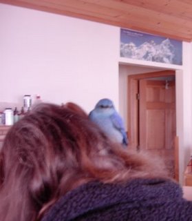
After this picture was taken, Rachel lowered her head into a large box until so we could get the bluebird to jump into the box. Then we put a blanket over th box so that the poor bird could rest and regain his composure.
About half an hour later, we heard scratching coming from the box. Rachel took the box outside and the bluebird, now his happy normal self, took of for the sky.
Birds arrive this time of year from their annual migration. Sometimes, the learning curve in their new environment can be a little steep. I've actually seen bluebirds repeatedly attack their own reflection in the window as they attempt to establish their new territory. I hope that this bluebird learned that he is no threat to himself as long as he does not do battle with his own reflection!
May we all find our happiness by learning that it does not serve us to battle with ourselves. Food for thought.
Wednesday, April 19, 2006
Latest funny videos, images, games & silliness
The following site tracks what people find interesting and then posts the most popular. Come back often because the list changes all the time.
Latest funny videos, etc
PS. I'd love to put their little widget here for doing this automatically, but blogger does not allow javasript.
Latest funny videos, etc
PS. I'd love to put their little widget here for doing this automatically, but blogger does not allow javasript.
Thursday, March 23, 2006
Massive Elk Invasion
A few times a year the elk come through the neighborhood here. Today was one of those days. I'll have some megabytage (the digital equivalent of "footage") as soon as I can edit it down and get Google to host it for me.
Tuesday, March 14, 2006
[puma-news] plants website
Hey Dan and Jennifer,
I'm glad you listened and finally put up that site Thankyou.
Here's the announcement email.
I'm glad you listened and finally put up that site Thankyou.
Here's the announcement email.
Dear Friends,
Dan finally succeeded, and here is the first part of this project. He
made me do it --- otherwise I'm sure I'd still be talking about it ten
years from now. Anyway, It isn't finished, probably never will be, and
it may contain inaccuracies which I hope to correct as time goes by. I'm
only up to the Mint family, and have to go all the way to Violet. I
think the Noxious Plant part is pretty much done. We plan to add a color
guide, but haven't gotten to it yet.
As you will notice, the accompanying text isn't in scientific jargon.
This is for two reasons. 1) I can't seem to stay serious, and 2) Dan
said he thought it would be more useful to more people if it isn't
strictly scientifically rigorous.
So, here's a beginning! Thanks to all of you who requested this. Send
me any comments, pro or con, that you wish. I'm moving to Africa now.
http://www.plantsofmagnolia.net
Best,
Jennifer
Saturday, March 11, 2006
[puma-news] Comments on USFS Rural School land sale
TO: USFS Rural School land sales adminstrators
I am writing to express my outrage at the proposed USFS Rural Schools land sale.
First. It is totally unacceptable to sell irreplaceable public land held in trust by the US Forest Service in order to provide temporary funding for rural schools.&! nbsp; Proceeds from the proposed sale are truly negligible compared to the huge debt created by the Bush administration’s mismanagement and malfeasance. It represents sacrifice of a valuable resource for inconsequential gain. I acknowledge that the United States faces a financial crisis, however I maintain that sale of our heritage is an extremely shortsighted and irresponsible idea - and sets a reckless precedent for the future of public lands owned by all US citizens.
Second. The notification method and public comment period has been handled so very poorly, that it begs suspicion of a deliberate smoke screen. The website www.geocommunicator.gov is cumbersome and difficult to use, with many discrepancies between tabulated data and graphic representation. A parcel marked for sale in the Magnolia Road area (Township 1S Range 72W) that was visible on March 9, was missing from view on March 11, even though the last acknowledged update occurred on February 24. I believe the parcel that mysteriously disappeared was known as "section 40", and was located on the north side of Magnolia Road at approximately mile 7.5, locally known as the "Boy Scout Rocks", and contiguous to a lar! ger parcel.
In spite of the poor maps and descriptions provided, it is obvious that the character of the lands proposed for sale has been grossly misrepresented. Supposedly, the parcels are “isolated or inefficient to manage” – but study of the on-line map shows that, at least in my local area, the forest service has selected prominent local landmarks, such as Turtle Rock, (T1SR72W Section 15, USFS Parcel Label NENE). Sale of the other parcels straddling Magnolia Road (T1SR72W, Sections 19, 20, 21 and 40) will effectively eliminate all public access to USFS l! and from Magnolia Road and County Road 97. It seems obvious that these lands were chosen for their commercial value as real estate, and not because they were inaccessible or “isolated”.
Third. The 305,000 acres earmarked for sale are owned by all Americans, an irreplaceable resource held in trust by the US Forest Service. My husband and I happen to own a home within the shadow of the local landmark known as Turtle Rock (T1SR72W Section 15, label NENE), on! e of the parcels designated for sale. We have lived here for 22 years, and have good reason to spend the considerable time and effort required to identify the local parcels marked and listed (poorly) on the Geocommunicator website. I am concerned that most citizens will believe the false descriptions, trust the agency charged with preservation of their wildland heritage, and think they are losing nothing of value. That conclusion would be wrong – and would result in another egregious violation of the public trust by the Bush adminstration.
In summary, I urge you to abandon this bizarre and ill-advised plan and remove all 304,370 acres from consideration for sale.
In particular, I object to sale of the following parcels within Roosevelt National Forest, T1SR72W, Sections 15, 19, 20, 21 and 40.
Sincerely,
Kathryn J. Teuber
28 Frontier Lane
Magnolia Star Route
Nederland, CO 80466
! 303-258-7548
Wednesday, March 08, 2006
[puma-news] Land Sales Initiative in Boulder County
I think the following is very well written and can be used as a model for other letters of concern:
To Whom It May Concern:
To Whom It May Concern:
A resident of the Aspen Meadows Subdivision (near Magnolia Road and
County Road 68) for 18 years, I feel obligated to speak out against your
land sale proposal (Land Sales Initiative in Boulder County). First of
all, let me express my disappointment in the limited time that has been
alloted for community feedback, as well as the cumbersome and poorly done
online map provided as a resource for this comment period.
My opposition refers to the Township, Range, and Sections below (any
inaccuracies due to difficulty of interpretation of online map ):
inaccuracies due to difficulty of interpretation of online map ):
Magnolia Road
Township 1S Range 72W
Section 19 - 40 acres
Section 20 - 193 acres Map shows 233)
Section 21 - 160 acres
Section 40 - 40 acres (Map shows 200 acres)
Total Acreage: 473 in the list, 633 on the map
Township 1S Range 72W
Section 19 - 40 acres
Section 20 - 193 acres Map shows 233)
Section 21 - 160 acres
Section 40 - 40 acres (Map shows 200 acres)
Total Acreage: 473 in the list, 633 on the map
All the areas listed above provide necessary wildlife habitat and offer
natural movement corridors for ungulates (specifically elk), bear, mountain lion,
bobcat, fox and coyote. Increased disturbance as a result of
development, will undoubtedly increase the stress on the species living in these
natural movement corridors for ungulates (specifically elk), bear, mountain lion,
bobcat, fox and coyote. Increased disturbance as a result of
development, will undoubtedly increase the stress on the species living in these
urban/wildlife interface lands. Over the past several years, developed land has
resulted in the rapid spread of non-native species of plants, high levels of erosion,
diminished feeding,mating, and birthing grounds, as well as decreased habitat for
a varietyof species from the mountain meadow vole to our state flower,
the Columbine, to the Golden Eagle nesting in the rock above.
This obviously politically motivated proposal, whether or not it is guised in
something as seemingly well intentioned like funding for rural schools,
is a disgrace. Once these lands are sold, it is rather evident that new
ones will be proposed in the name of some other manipulative cause. The
justification for selling them as "not being able to be sufficiently
managed" speaks volumes as to priorities. Instead, might it be a better
choice to consider something much greater than ourselves, the need for
space for all the non-human creatures that exist here and to offer ways
to conserve that space. No matter how small or seemingly insignificant
these lands might appear on a map, they all serve an important and necessary
function for wildlife and native plant species.
When decisions are made that continue to erode away
even the smallest bits and pieces of land that have been set aside such
as our nation's Roosevelt National Forest, along with wildlife, we as a society
suffer. If anything, as a People, we should be doing everything we can
to protect and preserve by purchasing additional lands not selling them off.
even the smallest bits and pieces of land that have been set aside such
as our nation's Roosevelt National Forest, along with wildlife, we as a society
suffer. If anything, as a People, we should be doing everything we can
to protect and preserve by purchasing additional lands not selling them off.
If for no other reason than to preserve our current Roosevelt National
Forest for the future generations, it is time to act in a thoughtful,
visionary way that holds the faith of the public that our National
Forests will remain the last haven for that herd of elk that passes
through on its journey to summer grounds, seven generations from now.
Forest for the future generations, it is time to act in a thoughtful,
visionary way that holds the faith of the public that our National
Forests will remain the last haven for that herd of elk that passes
through on its journey to summer grounds, seven generations from now.
As we whittle away at nature, so too do we whittle away at ourselves.
I am trusting you to do the right thing and not sell off any portion of
these lands listed above, as well as all others being considered.
these lands listed above, as well as all others being considered.
Sincerely,
Sharon Ticehurst
72 Meadowland Ct., Nederland, CO
(303) 449-1789
72 Meadowland Ct., Nederland, CO
(303) 449-1789
Monday, March 06, 2006
Instantly transport yourself to a ridge right next to the continental divide
This is just to cool!
But let me digress for just a moment.
A few years ago, I used to live in a town outside Boulder Colorado called Niwot. There's a lot of history that goes with the name that I won't get into right here. But suffice it to say that living in the town of Niwot endeared me to the name. There's another Niwot around as well. In fact, I and a somewhat supernatural experience right at the base of the other Niwot, which is Niwot Rigdge. Again, I'm trying to not get of on to many tangents.
Anyway, I've had a few enjoyable hikes up on Niwot Ridge. I've never gotten all the way to the end of it, and I've always wondered what the view from there would be. Well, (my point, finally) I now have a way to visit the far western end of Niwot Ridge any time I want.
You see, they've got a web cam up there.
So What? I've got a webcam right here at Lazy Z Web Cam.
But this is not just any old web cam.
No.
You'll get a kick out of it. This is a fully weather proofed pan and tilt cam. This means that you an look ALL around and zoom in and out as well.
Really. Try it. Click the link. Niwot Ridge Web Cam
Thanks Niwot Ridge LTER for making this available to us all!
[puma-news] Hopefully helpful map plus coordinates
Dear friends,
Here is more info. I have given local descriptions to the parcels in hopes of clarifying locations.
Also, here is Dave Hallock's input on Magnolia parcels: My editorial comments are in italics.
Magnolia Road
Township 1S Range 72W
Section 19 - 40 acres {I, Jennifer, believe he means Section 15, not 19. It would include the Turtle Rock, Range Road, and (Bennett/Spangler Parcels. My estimate shows 200 acres. Descriptions: Turtle Rock Parcel - NE1/4 of NE1/4 of Section 15, T1S, R72W; Range Road Parcel - NE1/4 of SW1/4, NW1/4 of SE1/4, and SW1/4 of SE1/4 of Sectrion 15, T1S, R72W; Bennet/Spangler Parcel - NW1/4 of NW1/4 of Section 15, T1S, R72W.)
Section 20 - 193 acres Map shows 233. (Reynolds Open Space and Loop Trails Parcel. Descriptions: Reynolds Open Space - SE1/4 of Section 20, irregular pieces of SW1/4 of Section 20, T1S, R72W. Loop Trail Parcel - NE1/4 of NW1/4 of Section 20, T1S, R72W.)
Section 21 - 160 acres ( Lazy z Parcel, 40 acre parcel southwest of Boy Scout Trails, and Rt 97 Parcel. Descriptions - Boy Scout Parcel - NW1/4 of NE1/4 of Section 21, T1S, R72W. Lazy z Parcel - SE1/4 of NE1/4 of Section 21, T1S, R72W. Rt. 97 Parcel - SW1/4 and SE1/4 of SE1/4 of Section 21, T1S, R72W.)
Section 40 - 40 acres (Map shows 200 acres) (Sections only go from 1 to 36, so I'm not sure what he means.)
Total Acreage: 473 in the list, 633 on the map
Values and Conservation Context: These lands are part of an elk/wildlife movement corridor between Winiger Ridge and lands west of the Peak-to-Peak Highway, and within elk winter range. They are designated as an Overland Habitat Connector on the Environmental Conservation Areas map of the Boulder County Comprehensive Plan. Some of the parcels (those in Sections 19, 20, and a portion of 21) are adjacent to Reynolds Ranch Open Space and other County Open Space acquisitions in the area. Some of the parcels in all four sections are adjacent to other National Forest lands. The parcels in Section 19 south of Nederland contain public trails.
Me speaking again ---
Our local concerns are with our elk habitat, fragmentation of habitat for birds and small mammals, including bobcats, plus our personal reasons for living here.
Funding for rural schools needs to come from a source more consistant than a one-time land sale of parcels that have local importance to their surrounding communities and wildlife.
All our parcels are in T1S, R72W. When referring to them, you must also use the description I have listed for each, i.e., SW1/4 of NW1/4, etc, including the Section number and Township and Range.
I really couldn't send out a smaller map, so I apologize to anyone whose computer burps and falls over. Dan says the official maps from USFS, etc, are "junk." What ridiculously cumbersome mapping programs!
Please also read Dave Halleck's complete comments in Scott's email about USFS Secure Rural Schools Land Sales Initiative. And, for extra oomph, follow the "discussions" on Puma-news!
Best to all,
Jennifer
Here are people to contact, including the USFS email address:
Senator Wayne Allard
Washington D.C. telephone 202-224-5941
District telephone 303-220-7414
Senator Ken Salazar
Washington D.C. telephone 202-224-5852
District telephone 303-455-7600
Rep. Mark Udall
Washington D.C telephone 202-225-2161
District Office telephone 303-650-7820
SRS_Land_Sales@fs.fed.us
[puma-news] land sale
I was concerned, when I first wrote, that this had slipped under the radar, even of PUMA news-readers, but I see that has changed.
I think Dave Hallock’s assessment is a very valid one for this area, in terms of the overall picture of the value of small parcels of national forest. One does have to look at the surrounding land ownership, animal migration patterns and other uses of the land to assess whether there is more value to a small portion of national forest than appears on the map. It was also quite obvious, from the original map Dan sent out, that some of the ‘small parcels’ are actually contiguous with larger parcels and those ‘small parcels’ are what provide access to the larger portion of national forest (note how many parcels cross or touch roads). The next round of land sales will probably put those larger parcels on the block, because they are inaccessible. When you consider management & maintenance expense, be aware that many of these parcels have just been ‘maintained’, at considerable expense to the taxpayers. Many of the parcels marked for sale are the same parcels, which were just thinned (over many objections- including the USFS track record of cutting & running), and which the USFS promised to monitor and use as models for further projects. Is it any wonder that many of us have little faith in the judgment of the USFS.
Terry is right that our National Forest is our land for the future. If there were truly a good reason for selling certain parcels to gain other parcels, which would add to the value of the forest, as a whole, then it may make sense to sell certain parcels. This issue is not a matter of forest management, no matter what whitewash the USFS uses; the National Forest does not even get the money.
The issue here is whether we should sell our land to fund our schools. What are we leaving for our children? Our schools should be funded by our taxes. If we weren’t spending so much in Iraq or on “congressional pork”, perhaps we could afford to fund our schools. Should we sell the Lincoln memorial to the Chinese to fund school lunches? Or, perhaps we could sell the White House to raise money for Social Security… The point is we shouldn’t be selling off our precious, finite forests to make up for budget shortfalls. This is what I meant by lambasting the proposal.
This has not yet been approved by Congress, so write your Senators and Congressmen. If enough voices speak out, we might actually be heard.
Vivian
[puma-news] Fw: [nature-net] USFS Secure Rural Schools Land Sales Initiative
This commetary is preliminary. From Dave Hallock of the County Open Space
research and management...Dave has worked alongside PUMA on many previous
projects. He is a top notch scientist and intelligent analyst. Below are
his initial comments regarding the Forest Service proposed land sales --
PUMA should study this as a way to build our own commentary. By the way,
the previous email regarding the map of land sales still has some
innaccuracies and problems, due mostly to inaccuracies and inconsistencies
in FS data. On that map web page are some additional comments regarding
this proposed sale. Letters, call, emails and faxes should start to go out
from willing participants and PUMA as a whole by the end of this week.
Here's a preliminary list of contacts for those who would like to get
started.
Their numbers are:
Senator Wayne Allard
Washington D.C. telephone 202-224-5941
District telephone 303-220-7414
Senator Ken Salazar
Washington D.C. telephone 202-224-5852
District telephone 303-455-7600
Rep. Mark Udall
Washington D.C telephone 202-225-2161
District Office telephone 303-650-7820
Comments on the proposed list must be received by March 30 and may be sent
by e-mail to SRS_Land_Sales@fs.fed.us. Written comments may be sent to: USDA
Forest Service, SRS Comments, Lands 4S, 1400 Independence Ave., SW, Mailstop
1124, Washington, DC, 20250-0003. Send faxed comments to (202) 205-1604.
Hallock's letter below.
Scott
******************************
Scott Campbell Reuman
Artist/Writer
Conundrum Designs, Inc.
Nederland, CO
http://www.conundrumdesigns.com
scottreuman@conundrumdesigns.com
----- Original Message -----
From: "David H Hallock" <eldoradh@rmi.net>
To: "BCNA Nature Net" <nature-net@yahoogroups.com>
Sent: Friday, March 03, 2006 7:30 AM
Subject: [nature-net] USFS Secure Rural Schools Land Sales Initiative
----------------------------------------------------------------------------------------------------
Secure Rural Schools Land Sales Initiative in Boulder County
These are my initial comments on the proposed land sale in Boulder County.
I have focused on land use issues.
Dave Hallock
Background
The Forest Service is seeking comments from all interested individuals and
organizations on the list of National Forest System land parcels in the FY
2007 President's Budget proposal to be sold for the purpose of funding
payments to Secure rural Schools. These funds will be used to offset
declining revenues that historically were derived from timber sales.
Comments should be submitted by March 30, 2006. They should pertain to the
list of land parcels proposed for sale. Comments should be submitted by
e-mail to SRS_Land_Sales@fs.fed.us, by facsimile to (202) 205-1604, or by
mail to USDA Forest Service, SRS Comments, Lands 4S, 1400 Independence Ave.,
SW., Mailstop 1124, Washington, DC 20520-0003. Electronic submission is
preferred.
Additional information about the Secure Rural Schools Land Sales Initiative
can be found at: http://www.fs.fed.us/land/staff/disposal.html. For maps of
the lands proposed for sale, go to:
http://www.fs.fed.us/land/staff/rural_schools.shtml. Go into
Geocommunicator.gov for the maps. (Note: the Geocommunicator.gov map site
had been problematic in correctly running and pulling up the maps).
Land Sales Initiative in Boulder County
The parcels proposed for sale in Boulder County lie within 10 geographic
areas, which I have used for description below. The spreadsheet list of
parcels on the USFS web site totals approximately 2,120 acres, while the map
indicates approximately 3,120 acres. And, there are some discrepancies on
the list between the legal descriptions and the acreages.
The overall justification for selling these parcels by the Forest Service is
that they are isolated from other contiguous National Forest System lands,
and because of their location, size, or configuration are not efficient to
manage as a component of the National Forest System. The isolation and
small size for some of the parcels appears true, but not for all.
My greatest concern is that there appears to be no recognition of the
conservation context of the parcels. When you look at all conserved lands
in western Boulder County, including Boulder County Open Space and other
private conservation easements (including some held by Colorado Open Lands
and The Nature Conservancy), then these parcels appear isolated and small
only in terms of ownership but not in terms of function. Some of the
parcels border Caribou Ranch Open Space, Reynolds Ranch Open Space, and Hall
Ranch Open Space. Some of the parcels are adjacent to lands with
conservation easements, such as Arapaho Ranch Wildlife Preserve and the
Welch Ranch. In some places, Boulder County Open Space has been filling in
the gaps between smaller parcels of Forest Service Land by purchasing the
intervening mining claims, such as on Spencer Mountain in Eldora and in
Lefthand Canyon. Two of the parcels have the Peak-to-Peak Scenic Byway
running through them, including one in Allenspark. Several parcels along
Magnolia Road are important wildlife movement corridors as are parcels near
the top of Spencer and Ute Mountains near Eldora. One group of parcels
appears to contain golden eagle nest sites and is popular for rock climbing
in Boulder Canyon. Another parcel contains a portion of the South St. Vrain
Creek and a portion of the South St. Vrain trail. Several of the parcels
near Nederland contain trails.
The result of this land sale is an increased fragmentation of the landscape.
The County and other property owners and land trusts have been filling in
the gaps within the National Forest Boundary and conserving lands; this is
good ecosystem planning This proposal creates new in-holdings within the
overall conservation context of western Boulder County; this is bad
ecosystem planning.
Additionally, the process appears very rushed. We have one month to make
comments for something that has some significant long-term land use impacts.
And it has not been easy accessing the Forest Service maps on their web
site. And there are discrepancies between the legal descriptions on the
USFS list and acreages, as well as what is presented on the maps.
What follows are geographic area descriptions of the parcels proposed for
sale, their conservation context, and some of their conservation value. The
geographic area descriptions are mine. When commenting to the Forest
Service you need to use National Forest Name (Roosevelt),
Township/Range/Section.
Magnolia Road
Township 1S Range 72W
Section 19 - 40 acres
Section 20 - 193 acres Map shows 233)
Section 21 - 160 acres
Section 40 - 40 acres (Map shows 200 acres)
Total Acreage: 473 in the list, 633 on the map
Values and Conservation Context: These lands are part of an elk/wildlife
movement corridor between Winiger Ridge and lands west of the Peak-to-Peak
Highway, and within elk winter range. They are designated as an Overland
Habitat Connector on the Environmental Conservation Areas map of the Boulder
County Comprehensive Plan. Some of the parcels (those in Sections 19, 20,
and a portion of 21) are adjacent to Reynolds Ranch Open Space and other
County Open Space acquisitions in the area. Some of the parcels in all four
sections are adjacent to other National Forest lands. The parcels in
Section 19 south of Nederland contain public trails.
Ridge Road
Township 1S Range 72W
Section 5 - 117 acres
Section 8 - 160 acres
Total Acreage: 277 acres on both list and map
Values and Conservation Context: In section 8, lands are adjacent to Rogers
Open Space and are part of the Open Corridor designation for Boulder Canyon
Highway (Boulder County Comprehensive Plan Open Space Element). Several of
the parcels in Section 5 are adjacent to USFS lands.
Caribou Ranch
Township 1N Range 73W
Section 34 - 30 acres
Section 36 - 80 acres (Map shows 160 acres)
Township 1S Range 73W
Section 1 - 20 acres
Total: 130 acres on list, 210 acres on map
Values and Conservation Context: These lands are integral parts of the
Caribou Ranch montane parkland, an area of exceptional biodiversity in
Boulder County, and winter, transitional range, and calving grounds for elk.
The lands in Sections 34 and 36 are within the Indian Peaks Environmental
Conservation Area, as designated on the Environmental Conservation Area Map
of the Boulder County Comprehensive Plan. The parcel in Section 34 is
totally surrounded by other conserved lands, including Boulder County Open
Space, City of Boulder, other Forest Service lands, and a conservation
easement on the only mining claim in the section. A portion of the lands in
Section 36 (E1/2 of SE ¼) is adjacent to other conserved lands (Conservation
Easement on Caribou Ranch) and other Forest Service lands. It contains an
existing trail along the Switzerland Trail railroad grade. A portion of the
lands in Section 36 (E1/2 of SE ¼) are adjacent to other conserved lands
(Caribou Ranch Conservation Easement) and are important for elk winter range
and as a movement corridor. The parcel in Section 1 is adjacent to the
Peak-to-Peak Scenic Byway.
Eldora
Township 1S Range 73W
Section 20 - 20 acres (Map shows all USFS lands in Section 20, which are
approximately 300 acres)
Total: 20 acres on list, approximately 300 acres on map
Values and Conservation Context: This is part of the entrance to the Indian
Peaks Wilderness Area, so the viewshed is of importance. Boulder County
Open Space has been acquiring many of the intervening mining claims on
Spencer Mountain. The ridgeline atop Spencer and Ute Mountains is an
important wildlife movement corridor. Portions of the parcels slated for
sale are adjacent to other Forest Service lands. Lands north of Middle
Boulder Creek are within the Indian Peaks Conservation Area, as designated
on the Environmental Conservation Area Map of the Boulder County
Comprehensive Plan.
Boulder Canyon to Sugarloaf Road and Sugarloaf Road East
Township 1N Range 72W
Section 25 - 120 acres
Section 35 - 240 acres
Section 36 - 240 acres (the legal in the list does not match the acreage,
which matches the map)
Township 1N Range 71W
Section 29 - 120 acres
Total: 720 acres on both list and map
Values and Conservation Context: Sections 35 and 36 are part of the scenic
backdrop to Boulder Canyon Highway and designated as an Open Corridor on the
Open Space Plan of the Boulder County Comprehensive Plan. The eastern
portion of Section 36 is within potential golden eagle nesting habitat (and
within the Wildlife Closure Area). There are popular rock climbing areas in
Section 36 (Security Risk). Portions of the parcels in Sections 35 and 36
are adjacent to Boulder Falls Open Space and within the Boulder Falls
Natural Area, as designated within the Boulder County Environmental
Resources Element of the Boulder County Comprehensive Plan.
Nederland
Township 1S Range 73W
Section 14 - 40 acres (Map shows 120 acres)
Total: 40 acres on list, 120 acres on Map
Values and Conservation Context: The NE ¼ of the SE ¼ of Section 14 is
adjacent to and functionally part of the Arapaho Ranch Wildlife Preserve, a
montane parkland that has exceptional biodiversity. The Arapaho Ranch is
under a conservation easement with Colorado Open Lands. Elk use the area as
transitional range and for calving. The parcel provides a buffer between
the Town of Nederland and the Arapaho Ranch. The parcel is designated
within the Indian Peaks Environmental Conservation Area on the Environmental
Resources Map of the Boulder County Comprehensive Plan.
Lefthand Canyon
Township 1N Range 72W
Section 1 - 240 acres
Total: 240 acres on list and map
Values and Conservation Context: Portions of these parcels are adjacent to
other National Forest lands on their north and west sides. Boulder County
Open Space has purchased almost all the mining claims within Section 1, as
well as other lands to the east and south. Lefthand Canyon is designated as
an Open Corridor on the Open Space Map of the Boulder County Comprehensive
Plan. Lands north of Lefthand Canyon Road are designated as part of the
Walker Mountain Environmental Conservation Area, as designated on the
Environmental Conservation Area Map in the Boulder County Comprehensive
Plan.
Overland Road and South St. Vrain
Township 2N Range 72W
Section 20 - 40 acres
Section 21 - 40 acres (80 acres are shown on the map)
Section 29 - 40 acres
Section 30 - 40 acres
Total: 160 acres on list, 200 acres on map
Values and Conservation Context: The parcel in Section 20 is adjacent to the
Peak-to-Peak Scenic Byway and is also adjacent to conservation easement
lands held by Boulder County and The Nature Conservancy. The South St.
Vrain Creek flows through the northwest corner of the parcel, designated as
an Open Corridor on the Open Space Map the Boulder County Comprehensive
Plan. The two parcels in Section 21 are adjacent to Conservation Easement
held by The Nature Conservancy. The Peak-to Peak Scenic Byway runs through
the parcel in Section 29. The parcel in Section 30 contains a portion of
the South St. Vrain Creek, designated as an Open Corridor on the Open Space
Map of the Boulder County Comprehensive Plan; this parcel also contains the
beginning of the South St. Vrain trail.
Allenspark
Township 3N Range 73W
Section 26 - 40 acres (120 acres shown on the map)
Total: 40 acres on list, 120 acres on map
Values and Conservation Context: The Peak-to-Peak Scenic Byway passes
through one of the parcels in Section 26. The parcel in the SE ¼ of the SW
¼ is adjacent to other National Forest lands.
Coffintop Mountain
Township 3N Range 71W
Section 21 - 40 acres (360 acres are shown on the map)
Total: 40 acres on list, 360 acres on map
Values and Conservation Context: These are some of the most important
ecological lands in Boulder County, being within the North St. Vrain
Ecological Conservation Area (Ecological Conservation Area Map, Boulder
County Comprehensive Plan), and designated as Core Habitat in the Forest
Plan. These lands are adjacent to Hall Ranch Open Space and Riverside Ranch
Open Space, and are adjacent to other National Forest lands on their south
side. This is habitat for bighorn sheep.
[Non-text portions of this message have been removed]
======================================================
Boulder County Nature Association's Nature Network
http://www.bcna.org
To Post a message, send it to: nature-net@yahoogroups.com
To Unsubscribe, send a message to: nature-net-unsubscribe@yahoogroups.com
To Subscribe, send a message to: nature-net-subscribe@yahoogroups.com
Message Archives: http://www.yahoogroups.com/group/nature-net
Unless otherwise stated, opinions expressed do not necessarily represent
BCNA's position. BCNA reserves the right to reject any message we feel is
inappropriate.
======================================================
Yahoo! Groups Links
<*> To visit your group on the web, go to:
http://groups.yahoo.com/group/nature-net/
<*> To unsubscribe from this group, send an email to:
nature-net-unsubscribe@yahoogroups.com
<*> Your use of Yahoo! Groups is subject to:
http://docs.yahoo.com/info/terms/
Subscribe to:
Posts (Atom)