Tuesday, December 11, 2012

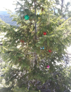
Walk-By Trail Side Christmas Tree Triming

Walk-by Christmas Tree TrimingThere is a fun little Christmas season tradition that happens every year around here.

One of the two routes I take to get from here to "the plains" is to go down coal creek canyon.  As you drive along, you'll see trees along the side of the road that have been decked out like christmas trees.

These are the so called "drive-by trimmings."

Well, this must have inspired somebody to give this same treatment to a local trail that runs along Winiger Ridge


Tuesday, October 16, 2012

The Elk Herd is In the Neighborhood

At dusk today, I saw a herd of about 60 elk going across the large meadow at about mile marker 10 on Magnolia.  I suspect the herd came down to this altitude from higher up because it looks like the nice fall weather is about to come to an end and it might snow at higher elevations.

Tuesday, September 04, 2012

Gross Reservoir Day


Gross Reservoir Day
This Sunday, September 9th, Noon-4pm
Join your neighbors at the North Shore Picnic Area of Gross Reservoir (where Gross Dam Road meets Flagstaff Road) for an afternoon picnic and several guided walks.  The event, hosted by TEG – The Environmental Group – is intended to bring the communities surrounding Gross Reservoir together in appreciation of everything the reservoir has to offer: magnificent vistas, diverse wildlife, maintained picnic areas, non-motorized boating, and hikes of varying intensity. 
The event is completely free and open to the public.  Bring a picnic (and your boat, if you have one).
No glass bottles/containers, and pets must be leashed.


Thursday, August 23, 2012

This is a Fine Example of What Joomla Can Do

I have relatives in Germany.  One of them has a nice looking site about jewelry rings.  You can see it at
http://www.ringekaufen.com/
Tip: Google Chrome will even translate it for you. The result is a bit rough, but you can usually figure out what is meant.

Thursday, August 02, 2012

Background Info on Yesterdays Fire

I checked on the fire this morning.  There's no smoke to be seen.

Claire Farley  writes:
 
I happened to be on Winiger Ridge this morning, and I spotted a fire that there has been some conversation about. Here are the photos of what I saw from the cut out log seats at the top of Winiger Ridge after I called 911.

I don't know the current status of the fire but there was a big response. The fire was on the south side of the ridge and working its way uphill. My greatest fear was that it would go over the ridge into the densely forested north-facing slope. It appeared that a helicopter was working that edge of the fire to prevent that from happening.

Many thanks to all of our firefighters!


And my neighbor Clark adds:

Concerning the start of the fire:  I'm pretty sure we saw/heard the bolt 
that started the fire.  I was near a window on the north side of our 
house Monday afternoon, around 4:30 pm or 5 pm, when there was a 
brilliant flash in the direction of the window and an almost 
simultaneous enormous crash of thunder.  I didn't actually see the 
lightning bolt, but it seemed to be in the direction where the fire 
turned out to start.  We monitored the area for the next hour, looking 
for smoke.  (As I mentioned in an earlier post, we are aware of no 
lightning in the area since late Monday.) 

What is disturbing is that the fire could smolder for nearly two days 
before erupting into flame.  It should be a learning moment for all 
concerned.  Some residents may recall the controlled burn on Winiger 
Ridge about a dozen years ago.  A day or two after the burn, a neighbor 
(there was nobody officially monitoring the aftermath of the controlled 
burn) noticed smoke and reported it: the fire had flared up and escaped, 
burning an additional 7 acres (only a few hundred feet from today's 
fire).  A couple days after that, my wife and I stomped out flames from 
the edge of the controlled burn farther east that were dangerously close 
to the lodgepole forest north of the crest of the ridge. 

There have been many small fires in the neighborhood during the last 
weeks.  Today's event should teach us that the modest amount of rain 
we've had recently has not cured the overall dryness.  We should keep 
alert to smoke, especially where there have been small fires recently or 
well-located lightning strikes. 

Thanks to everyone for watching and reporting about these threats and to 
the firefighters who responded very rapidly this morning. 

Clark (& Y) Chapman 
Lazy Z Rd., Nederland

Wednesday, August 01, 2012

Cats and Dogs

It is now raining cats and dogs and there is a lot of lightning.  I'm sure the firefighters are waiting it out in the thick trees right now. However, the ran is doing a great job of putting out any remaining smolders.

Lighting Delay

The 26 remaining fire fighters paused work while there was lightning danger.  But as of 3:30, they are back on the job putting out every last ember.

The yellow dots above are the fire fighters. They also have a ATV (middle) that is running back and forth across my yard with supplies.

Fire out.

The helicopter just left.  I can see the firemen leaving too.

Thanks everyone for all this quick work. This one was a bit to close to home.

Out by 2 pm

There are about 40 firefighters working the fire.  It is 24% contained as of 15 minutes ago.  They expect to have it out by 2 pm today .

They've put the helicopter on standby because there are no more large burning areas.

Awesome!

Lots of resources

There are a lot of firemen working the fire now, and a bucket helicopter is dropping water on it every few minutes.  Gross res. is a convenient local source of water for the helicopter.

Picture of Balancing Beam Rock Fire

Turns out I go hiking up to the exact area of the fire almost every day. 

The location of the fire is at the center of this map"
https://maps.google.com/maps?q=1987+Lazy+Z+Rd,+Nederland,+CO&hl=en&ll=39.953062,-105.416456&spn=0.002883,0.006968&sll=38.997934,-105.550567&sspn=5.983647,14.27124&oq=198&t=w&hnear=1987+Lazy+Z+Rd,+Nederland,+Colorado+80466&z=18


New Fire Near Here

I just talked to a fireman at the gate end of Lazy Z.  "There is a fire up on the hill, and I would get out of our way since there will be a bunch of fire trucks coming."

I turned around and almost ran into two fire trucks coming the towards me.


Monday, July 02, 2012

90% Containment

Yeah!  Enough said.

Saturday, June 30, 2012

Day 5: Making Good Progress


I read at http://boulderoem.com/emergency-status
that there is going to be a lot of back burning to increase the strength of the fire line.  I assume that is what the smoke is all about.

Friday, June 29, 2012

Day 4: The Great Smokies

It is quite smokey today.   I doubt the smoke is from the flagstaff fire since there is a steady breaze from the west.

Still, it makes it hard to see anything at all up here at 8300 feet and 4 miles west of  the flagstaff fire.

Thursday, June 28, 2012

Day 3: Rain is Good

There have been a number of thunder showers over the last day.  Although the associated lightning can spark new fires, it looks like all that has been happening is that the rain is helping to put out the flagstaff fire.

I took this picture about 4 pm.  There was just one small plume of smoke coming off the peak.

Wednesday, June 27, 2012

9news just came up here

I showed 9news a good place to get some footage of the fire from here.  Maybe I'll even make it into the news myself since they interviewed me about the flagstaff fire.

Map of the Flagstaff Fire

Here's something I've been looking for - a detailed terrain map of the location of the fire

http://yfrog.com/z/j2q3vjhj

Cool Time Lapse of the Boulder Flagstaff Fire

I shot this time lapse of the western side of the fire yesterday (Day 1).  I'm about 4 miles west of the fire, and alas, don't have the right telephoto lense for a better close up.  However the swirling smoke and clouds are fun to watch.  See the video here:
http://youtu.be/UugZKZ8AYN4

Another longer time lapse as seen from Boulder is at
http://ireport.cnn.com/docs/DOC-807894

Day 2 Morning Update of Boulder Flagstaff Fire

9 am.

The fire does not look like much from the west this morning.  However, there is a live video feed of it at:
http://www.9news.com/video/player_live_2.aspx

Another live stream (not as close up) is at

http://www.dailycamera.com/boulder-county-news/ci_20948526/boulder-flagstaff-fire-live-webcam-view-above-ncar

I find this map quite useful.   I'm reporting from a orange square just off the left edge of the map.

http://www.timescall.com/portlet/article/html/imageDisplay.jsp?contentItemRelationshipId=4487507
Also, here's a number I'll be keeping handy:
Emergency Operations Center has activated a call center for residents and others impacted by the fire to obtain information. The phone number is 303-413-7730. People seeking fire and evacuation information are encouraged to call this number. 

Tuesday, June 26, 2012

Rainbow Over Boulder Flagstaff Fire

A rain storm came through about 7 PM. At a bit after 8 pm, I noticed a faint rainbow hanging to the left over the burnt mountain side
The rain seems to have helped put the fire out.  I did not see any more crown fires!

Slurry Bomber Releases Load

6:30 PM Here is a slurry bomber releasing it's load over the Boulder flagstaff fire.  This picture is on the western flank of South Boulder Peak.

Boulder Flagstaff Fire

6:03 PM View of the #flagstaff (that's the twitter hashtag) fire. It looks more contained from this side relative to an hour ago.  A thunderstorm passed overhead about 2:30 here.  Rumor has it that it was lightning from this thunderstorm that started the fire.


The black smudge above the mountain at the right is an air tanker. 

Here is a page with more useful links about the boulder flagstaff fire:
http://www.fricklas.com/boulderfirelinks/

Tuesday, May 22, 2012

Cool Time lapse

There is a saying here in Colorado, "If you don't like the weather, just wait 5 minutes." That certainly was true on this day. Clouds are swirling around every which way. At one point, you have one layer of clouds heading west, while a higher layer of clouds is heading its. This short time laps captures it all for May 13, 2012 near Pinecliff, Co

Check it out at http://youtu.be/8tLg1RGjGac

Monday, April 02, 2012

Tick, Tick, Tick

It's been the driest March on record. It has also been quite warm the last couple of weeks, and the ticks have noticed.

I first saw a one tick about a week ago, and on April fool's day I saw two more on me. (That's no April Fool's Joke either.)

Also, for the first time EVER, I've been able to get a respectable tan in March up here in the mountains. Hmmmm... Global Warming anybody?

Today, it's returned to a more seasonable weather, with just a touch of snow. We can certainly use the moisture!

Friday, March 16, 2012

The spring melt is here

This past winter has been unusual in that I've had more days then ever before where I could x-c ski in my own yard. But this all came to an end about a week ago. We've had a sold stretch of warm melting weather and much of the snow is now gone, and the ice columns stretching from the roof to the ground have come crashing down.

I've even discovered two missing newspapers at the bottom of the driveway. The first was from February 3. And then... as the snow receded even further, I found a paper from December 1. These papers are presumably from the days when the heavy snows that formed the base for my ski-able yard came from.

Tuesday, February 28, 2012

Moose on the loose.


There's been a moose in the neighborhood of Nederland in the last few weeks. I saw it crossing a meadow below Barker Resevour.

... and a neighbor took this picture earlier today.